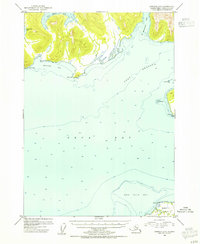
1953 Map of Cordova C-7
USGS Topo · Published 1954About this map
Port Gravina and the northern reaches of Orca Bay dominate this 1953 topographic survey, revealing a landscape defined by deep fjords and maritime navigation within the Chugach National Forest. The map details the intricate shoreline of Prince William Sound, featuring prominent landforms such as Knowles Head and Red Head which frame the entrance to Knowles Bay. To the northeast, the narrow inlet of St Matthews Bay and the descriptive Hells Hole suggest the varied coastal conditions encountered by mid-century mariners.
Find a feature on this map
16 named features on this map. Tap any name to fly to it.
Don’t see what you’re looking for? This feature index may not catch every label — zoom into the map to look around manually.
Map Details
Editions of this 1953 Cordova C-7 Map
2 editions found
Other maps of this area

1948 · Cordova
USGS Topo · 1:250,000

1950 · Cordova C-7
USGS Topo · 1:63,360

1950 · Cordova C-6
USGS Topo · 1:63,360

1950 · Cordova B-7
USGS Topo · 1:63,360

1950 · Cordova D-7
USGS Topo · 1:63,360

1950 · Cordova C-8
USGS Topo · 1:63,360

1951 · Cordova
USGS Topo · 1:250,000

1951 · Cordova D-8
USGS Topo · 1:63,360

1951 · Cordova D-6
USGS Topo · 1:63,360

1951 · Cordova B-8
USGS Topo · 1:63,360