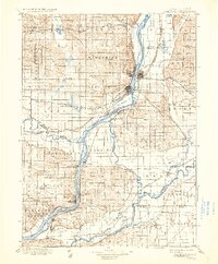
1899 Map of Cordova
USGS Topo · Published 1936About this map
The Mississippi River serves as the dominant geographic spine of this late 19th-century survey, defining the border between Iowa and Illinois. The landscape is characterized by a sophisticated network of late-Victorian rail infrastructure, including the Chicago and Northwestern and the Chicago Milwaukee and St. Paul, which connect riverfront hubs like Clinton and Lyons. Significant waterway confluences are visible where the Wapsipinicon River and Rock River meet the Mississippi, creating a complex environment of islands and lowlands such as Big Beaver Id. and the wetlands around Goose Lake. Local life is anchored in numerous small settlements and townships, from the river landings at Cordova and Port Byron to the inland rail stops at Low Moor and Erie. The map meticulously details the section lines and township boundaries that organized these fertile river valleys during a period of intense agricultural and industrial expansion.
Find a feature on this map
112 named features on this map. Tap any name to fly to it.
Don’t see what you’re looking for? This feature index may not catch every label — zoom into the map to look around manually.
Map Details
Editions of this 1899 Cordova Map
5 editions found

Other maps of this area

1891 · DeWitt
USGS Topo · 1:62,500

1891 · Davenport
USGS Topo · 1:62,500

1891 · Maquoketa
USGS Topo · 1:62,500

1891 · Clinton
USGS Topo · 1:62,500

1892 · Goose Lake
USGS Topo · 1:62,500

1892 · Savanna
USGS Topo · 1:62,500

1892 · Leclaire
USGS Topo · 1:62,500

1893 · Leclaire
USGS Topo · 1:62,500

1894 · Goose Lake
USGS Topo · 1:62,500

1894 · Clinton
USGS Topo · 1:62,500