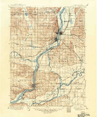
1899 Map of Cordova
USGS Topo · Published 1949About this map
The Mississippi River serves as the central artery for this late 19th-century survey, dividing the landscapes of Iowa and Illinois near the bustling river towns of Lyons, Clinton, and Fulton. This era of development is defined by an intricate web of transportation, where the Chicago and Northwestern Ry and the Chicago Milwaukee and St. Paul railroads converge at the river's edge, facilitating trade between the expanding riverfront settlements and the interior farmsteads.
Find a feature on this map
93 named features on this map. Tap any name to fly to it.
Don’t see what you’re looking for? This feature index may not catch every label — zoom into the map to look around manually.
Map Details
Editions of this 1899 Cordova Map
5 editions found

Other maps of this area

1891 · DeWitt
USGS Topo · 1:62,500

1891 · Davenport
USGS Topo · 1:62,500

1891 · Maquoketa
USGS Topo · 1:62,500

1891 · Clinton
USGS Topo · 1:62,500

1892 · Goose Lake
USGS Topo · 1:62,500

1892 · Savanna
USGS Topo · 1:62,500

1892 · Leclaire
USGS Topo · 1:62,500

1893 · Leclaire
USGS Topo · 1:62,500

1894 · Goose Lake
USGS Topo · 1:62,500

1894 · Clinton
USGS Topo · 1:62,500