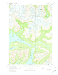
1951 Map of Cordova D-6
USGS Topo · Published 1974About this map
Port Fidalgo and Port Gravina define the intricate coastline of this 1951 coastal Alaskan survey, revealing a landscape shaped by glacial activity and deep-water inlets. The topography is dominated by the steep ascent toward Meteorite Mtn and the expansive ice fields marked by numerous crevasses at the northern heights. A solitary cabin situated along the northern shore of Port Fidalgo suggests the seasonal or subsistence-based human presence common in the region during the mid-20th century. The intricate drainage systems, including the West Fork and East Fork of Olsen Creek, lead into sheltered waters like Olsen Bay, highlighting the complex hydrology of the Chugach National Forest. The map also details early geodetic control points such as VABM Duck and VABM Bar, which were essential for mapping these remote stretches of the Prince William Sound area.
Find a feature on this map
23 named features on this map. Tap any name to fly to it.
Don’t see what you’re looking for? This feature index may not catch every label — zoom into the map to look around manually.
Map Details
Editions of this 1951 Cordova D-6 Map
3 editions found
Other maps of this area

1948 · Cordova
USGS Topo · 1:250,000

1950 · Cordova C-7
USGS Topo · 1:63,360

1950 · Cordova C-6
USGS Topo · 1:63,360

1950 · Cordova D-7
USGS Topo · 1:63,360

1950 · Cordova D-5
USGS Topo · 1:63,360

1951 · Cordova
USGS Topo · 1:250,000

1951 · Cordova C-5
USGS Topo · 1:63,360

1951 · Cordova D-6
USGS Topo · 1:63,360

1951 · Valdez A-6
USGS Topo · 1:63,360

1952 · Valdez
USGS Topo · 1:250,000