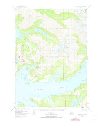
1950 Map of Cordova D-7
USGS Topo · Published 1973About this map
Chugach National Forest dominates this coastal landscape, where high mountain peaks descend sharply into the intricate inlets of the Prince William Sound region. The terrain is defined by the massive Silver Glacier and notable summits like Mt Denson and Billygoat Mountain. Water defines every border, from the deep waters of Port Fidalgo to the sheltered recesses of Landlocked Bay and Galena Bay. This coastal geography created a natural isolation for early industrial efforts, evidenced by a solitary Mine located on the eastern shore of St Matthews Bay. The map captures a wilderness in transition, where names like Copper Mountain Peninsula and Vesuvius Valley hint at the geological and mineral interests that drew early 20th-century explorers and prospectors to these remote Alasken shores before the mid-century mapping effort.
Find a feature on this map
40 named features on this map. Tap any name to fly to it.
Don’t see what you’re looking for? This feature index may not catch every label — zoom into the map to look around manually.
Map Details
Editions of this 1950 Cordova D-7 Map
3 editions found
Other maps of this area

1948 · Cordova
USGS Topo · 1:250,000

1950 · Cordova C-7
USGS Topo · 1:63,360

1950 · Cordova C-6
USGS Topo · 1:63,360

1950 · Cordova D-7
USGS Topo · 1:63,360

1950 · Cordova C-8
USGS Topo · 1:63,360

1951 · Cordova
USGS Topo · 1:250,000

1951 · Cordova D-8
USGS Topo · 1:63,360

1951 · Cordova D-6
USGS Topo · 1:63,360

1951 · Valdez A-6
USGS Topo · 1:63,360

1952 · Valdez
USGS Topo · 1:250,000