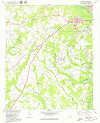
1979 Map of Cordova
USGS Topo · Published 1979About this map
The North Fork Edisto River meanders along the eastern edge of this South Carolina landscape, defining the boundary for the rural community of Cordova. By the late 1970s, the area maintained a distinct balance between its agricultural roots and burgeoning infrastructure. The Seaboard Coast Line railroad cuts diagonally across the terrain, serving the timber and farming interests of the region through stops like Simons Siding.
Find a feature on this map
49 named features on this map. Tap any name to fly to it.
Don’t see what you’re looking for? This feature index may not catch every label — zoom into the map to look around manually.
Map Details
Editions of this 1979 Cordova Map
2 editions found
Other maps of this area

1919 · Bamberg
USGS Topo · 1:48,000

1920 · Bamberg
USGS Topo · 1:62,500

1920 · Orangeburg
USGS Topo · 1:48,000

1921 · Orangeburg
USGS Topo · 1:62,500

1943 · Bamberg
USGS Topo · 1:62,500

1943 · Orangeburg
USGS Topo · 1:125,000

1943 · Orangeburg
USGS Topo · 1:62,500

1946 · Woodford
USGS Topo · 1:62,500

1946 · St. Matthews
USGS Topo · 1:62,500

1954 · Augusta
USGS Topo · 1:250,000