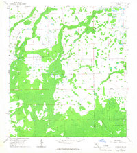
1958 Map of Corkscrew NW
USGS Topo · Published 1967About this map
Corkscrew Swamp dominates the southern landscape of this 1958 topographic survey, marking a significant ecological expanse across the Lee and Collier County line. The map highlights the early boundaries of the Sanctuary, a preserved wetland area that provides critical habitat for native Florida wildlife. The terrain is characterized by a complex network of wetlands and hammocks, including Panther Island, interspersed with a few agricultural clearings and a Flowing Well. Mapping here was largely completed via aerial photography and planetable surveys, revealing the intricate water patterns and unimproved dirt roads that defined the interior of Southwest Florida before mid-century development transformed the region. The lack of surveyed land lines in several townships reflects the area's transition from an inaccessible wilderness to a managed wilderness preserve.
Find a feature on this map
7 named features on this map. Tap any name to fly to it.
Don’t see what you’re looking for? This feature index may not catch every label — zoom into the map to look around manually.
Map Details
Editions of this 1958 Corkscrew NW Map
4 editions found
Other maps of this area

1956 · West Palm Beach
USGS Topo · 1:250,000

1957 · West Palm Beach
USGS Topo · 1:250,000

1958 · West Palm Beach
USGS Topo · 1:250,000

1958 · Corkscrew SE
USGS Topo · 1:24,000

1958 · Bonita Springs
USGS Topo · 1:24,000

1958 · Corkscrew NW
USGS Topo · 1:24,000

1958 · Estero
USGS Topo · 1:24,000

1958 · Alva SW
USGS Topo · 1:24,000

1958 · Corkscrew SW
USGS Topo · 1:24,000

1958 · Alva SE
USGS Topo · 1:24,000