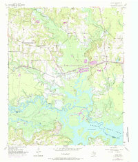
1955 Map of Corley
USGS Topo · Published 1985About this map
The Sulphur River and its meandering tributaries dominate the southern landscape of this mid-century survey, where the river's edge defines the boundary between Bowie Co and Cass Co. North of White Oak Ridge, the rail-oriented economy is evident along the St Louis Southwestern Railroad, which connects the small communities of Carbondale, Corley, and Simms. The terrain is characterized by numerous small branches, including Anderson Creek and Panther Creek, which feed into the larger reservoir of Wright Patman Lake. Purple revisions indicate expansion of the lake's controlled inundation area, which reached a normal pool elevation of 225 feet. Rural life is anchored by local institutions such as Old Union Ch, Mount Obie Ch, and Mt Pleasant Ch, each with nearby burial grounds including Old Union Cem and Irby Cem.
Find a feature on this map
32 named features on this map. Tap any name to fly to it.
Don’t see what you’re looking for? This feature index may not catch every label — zoom into the map to look around manually.
Map Details
Editions of this 1955 Corley Map
Other maps of this area

1909 · New Boston
USGS Topo · 1:62,500

1910 · Linden
USGS Topo · 1:62,500

1914 · Daingerfield
USGS Topo · 1:62,500

1930 · Bassett
USGS Topo · 1:62,500

1953 · Texarkana
USGS Topo · 1:250,000

1954 · New Boston
USGS Topo · 1:24,000

1954 · Hooks
USGS Topo · 1:24,000

1955 · Corley
USGS Topo · 1:24,000

1955 · Maud
USGS Topo · 1:24,000

1955 · New Boston
USGS Topo · 1:62,500