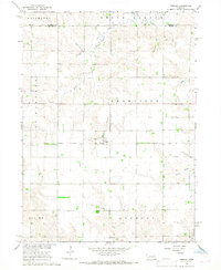
1966 Map of Cornlea
USGS Topo · Published 1968About this map
The village of Cornlea serves as a central point in this mid-1960s survey of the northern Nebraska plains, located just south of the Madison Co Platte Co line. The landscape is defined by the headwaters of several drainages, including the North Fork Union Creek and the meandering South Fork. A notable linear feature is the Old Railroad Grade that cuts through the town and the surrounding countryside, marking the former path of steam-era transportation.
Find a feature on this map
15 named features on this map. Tap any name to fly to it.
Don’t see what you’re looking for? This feature index may not catch every label — zoom into the map to look around manually.
Map Details
Editions of this 1966 Cornlea Map
2 editions found
Other maps of this area

1955 · Fremont
USGS Topo · 1:250,000

1957 · Fremont
USGS Topo · 1:250,000

1958 · Fremont
USGS Topo · 1:250,000

1963 · Madison
USGS Topo · 1:24,000

1963 · Battle Creek SE
USGS Topo · 1:24,000

1963 · Battle Creek SW
USGS Topo · 1:24,000

1966 · Tarnov
USGS Topo · 1:24,000
1966 · Lindsay SW
USGS Topo · 1:24,000

1966 · Platte Center
USGS Topo · 1:24,000
1966 · Lindsay
USGS Topo · 1:24,000