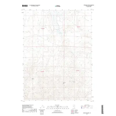
2018 Map of Cornucopia Ridge
USGS Topo · Published 2018About this map
Cornucopia Ridge defines the center of this terrain in Elko County, where high-altitude basin and peak geography dominates the landscape. The survey details the drainage of Sulphur Cr in the northeast and identifies isolated water sources such as Sulphur Spring and Allen Spring, which are critical landmarks in this arid environment. To the west, the broad depression of Wild Horse Basin sits below the elevation of Silver Peak. This 2018 edition provides a modern topographic record of the Public Land Survey System divisions, showing the boundaries for Townships 42 and 43 North across Ranges 50 and 51 East. The map is primarily a study of natural elevation and hydrology, capturing the character of the high Nevada backcountry as it appeared in the early 21st century.
Find a feature on this map
10 named features on this map. Tap any name to fly to it.
Don’t see what you’re looking for? This feature index may not catch every label — zoom into the map to look around manually.
Map Details
Editions of this 2018 Cornucopia Ridge Map
This is the sole edition of this map. No revisions or reprints were ever made.
Other maps of this area

1955 · McDermitt
USGS Topo · 1:250,000

1956 · Tuscarora
USGS Topo · 1:62,500

1956 · Mt. Blitzen
USGS Topo · 1:62,500

1956 · Bull Run
USGS Topo · 1:62,500

1959 · McDermitt
USGS Topo · 1:250,000

1964 · Wilson Reservoir
USGS Topo · 1:62,500

1982 · Bull Run Mts
USGS Topo · 1:100,000

1982 · Tuscarora
USGS Topo · 1:100,000
1987 · Cottonwood Peak
USGS Topo · 1:24,000
1987 · Fourmile Butte
USGS Topo · 1:24,000