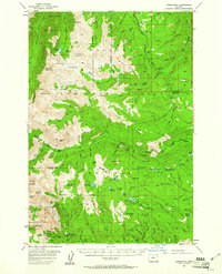
1954 Map of Cornucopia
USGS Topo · Published 1961About this map
Cornucopia Mines and the settlement of Cornucopia anchor the southern reaches of this 1954 survey, reflecting a landscape defined by high-altitude extraction and rugged administrative outposts. Situated within the Wallowa-Whitman National Forest, the map details a network of infrastructure supporting the Eagle Cap Wilderness Area and the Wallowa Mountain Sheep Refuge. These include isolated facilities like the Lick Creek Ranger Sta, Fish Lake Guard Sta, and the Trinity Guard Station.
Find a feature on this map
91 named features on this map. Tap any name to fly to it.
Don’t see what you’re looking for? This feature index may not catch every label — zoom into the map to look around manually.
Map Details
Editions of this 1954 Cornucopia Map
4 editions found
Other maps of this area

1915 · Pine
USGS Topo · 1:125,000

1954 · Cornucopia
USGS Topo · 1:62,500

1954 · Eagle Cap
USGS Topo · 1:62,500

1954 · Harl Butte
USGS Topo · 1:62,500

1955 · Baker
USGS Topo · 1:250,000

1955 · Grangeville
USGS Topo · 1:250,000

1957 · Enterprise
USGS Topo · 1:62,500

1957 · Joseph
USGS Topo · 1:62,500

1957 · Halfway
USGS Topo · 1:62,500

1957 · Homestead
USGS Topo · 1:62,500