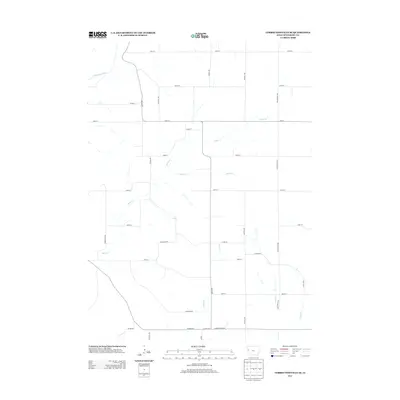
2013 Map of Correctionville SE
USGS Topo · Published 2013About this map
The Little Sioux River winds through the northwestern corner of this Woodbury County landscape, anchoring a drainage network of prairie creeks that define the local topography. Significant watercourses including Miller Cr, Keller Cr, and Dutch Cr carve across the section lines, highlighting the tension between the natural drainage patterns and the rigid agricultural grid. This 2013 survey illustrates a rural Iowa infrastructure dominated by a precise network of named avenues and streets, such as O'Brien Ave and Pocahontas Ave, which facilitate the region's farming economy. Near the southern boundary, thoroughfares like the Danbury Blacktop and Co Hwy-D54 provide critical connections to neighboring townships. Local family names or early settlers are reflected in landmarks like Millers Path, offering a spatial record of the area's rural development and land use in the early 21st century.
Find a feature on this map
31 named features on this map. Tap any name to fly to it.
Don’t see what you’re looking for? This feature index may not catch every label — zoom into the map to look around manually.
Map Details
Editions of this 2013 Correctionville SE Map
This is the sole edition of this map. No revisions or reprints were ever made.
Other maps of this area

1954 · Fort Dodge
USGS Topo · 1:250,000

1957 · Fort Dodge
USGS Topo · 1:250,000

1958 · Fort Dodge
USGS Topo · 1:250,000

1969 · Danbury
USGS Topo · 1:24,000

1969 · Holstein SW
USGS Topo · 1:24,000

1969 · Mapleton
USGS Topo · 1:24,000

1969 · Correctionville NW
USGS Topo · 1:24,000

1969 · Correctionville
USGS Topo · 1:24,000

1969 · Cushing
USGS Topo · 1:24,000
1969 · Smithland
USGS Topo · 1:24,000