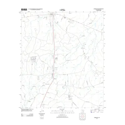
2013 Map of Corrigan
USGS Topo · Published 2013About this map
The timber-rich landscape of Polk County is dominated by the intersecting transportation corridors of Corrigan and Moscow. This 2013 survey illustrates a region where local geography is tied to a network of creeks, such as Long King Cr, Brushy Cr, and McManus Cr, which drain the wooded terrain. Named settlements like Asia, Snow Hill, and Bering suggest the area's deep-rooted community history, while several family and church-related landmarks provide essential data for genealogical research. These include the Burch Cem and locations identified by roads like Lyons Cemetery Rd and Pine Ridge Cemetery Rd. The map also captures several distinct local clusters such as Hall and Mack, Marshall, and Goliad, reflecting the dispersed nature of rural settlement in East Texas during the early 21st century.
Find a feature on this map
107 named features on this map. Tap any name to fly to it.
Don’t see what you’re looking for? This feature index may not catch every label — zoom into the map to look around manually.
Map Details
Editions of this 2013 Corrigan Map
This is the sole edition of this map. No revisions or reprints were ever made.
Other maps of this area

1927 · Lufkin 4-c
USGS Topo · 1:24,000

1932 · Manning
USGS Topo · 1:62,500

1953 · Palestine
USGS Topo · 1:250,000

1954 · Beaumont
USGS Topo · 1:250,000

1955 · Camden
USGS Topo · 1:62,500

1955 · New Willard
USGS Topo · 1:62,500

1957 · Beaumont
USGS Topo · 1:250,000

1957 · Palestine
USGS Topo · 1:250,000
1963 · Trevat
USGS Topo · 1:24,000
1963 · Wakefield
USGS Topo · 1:24,000