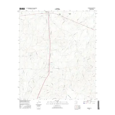
2016 Map of Corrigan
USGS Topo · Published 2016About this map
Corrigan serves as the primary hub in this northern Polk County landscape, situated at the junction of major transit routes and local paths like W Second St and S Home St. The area transitions from the more concentrated settlement of Corrigan southward toward Moscow, linked by a corridor of rural roads and loops such as Pine Hollow Loop. The terrain is deeply inscribed with a dense network of waterways, including Sand Cr and Long-King Cr, which carve through the land between smaller localities like Snow Hill and Pleasant Hill. Genealogists and local historians will find several family and community markers throughout the countryside, specifically Burch Cem and various access points like Adams Cemetery Rd and Lyons Cemetery Rd, reflecting the generational settlement patterns of east Texas.
Find a feature on this map
80 named features on this map. Tap any name to fly to it.
Don’t see what you’re looking for? This feature index may not catch every label — zoom into the map to look around manually.
Map Details
Editions of this 2016 Corrigan Map
This is the sole edition of this map. No revisions or reprints were ever made.
Other maps of this area
1927 · Lufkin 4-c
USGS Topo · 1:24,000
1932 · Manning
USGS Topo · 1:62,500

1953 · Palestine
USGS Topo · 1:250,000

1954 · Beaumont
USGS Topo · 1:250,000
1955 · Camden
USGS Topo · 1:62,500
1955 · New Willard
USGS Topo · 1:62,500

1957 · Beaumont
USGS Topo · 1:250,000

1957 · Palestine
USGS Topo · 1:250,000
1963 · Trevat
USGS Topo · 1:24,000
1963 · Wakefield
USGS Topo · 1:24,000