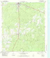
1984 Map of Corrigan
USGS Topo · Published 1984About this map
The town of Corrigan serves as the primary hub of this East Texas corridor, centered at the intersection of the Southern Pacific railroad and major highways. The map reveals a landscape defined by its timber and rail history, with the railroad line stretching south through Moscow toward Bering. Local genealogy is well-represented by several family-named burial grounds, including Burch Cem, Watts and Jones Cem, and Taylor Cem, which are scattered among the drainages of Bear Creek and Dry Creek. Rural life is anchored by community landmarks such as Shiloh Ch and Pine Hill Ch, while industrial activity is noted by Gravel Pits and various pipelines. The terrain is characterized by a dense network of seasonal and perennial streams like Brushy Creek and Kennedy Creek, which feed into the larger river systems of the region. This 1984 edition provides a detailed look at the rural infrastructure and land use prior to significant modern development.
Find a feature on this map
36 named features on this map. Tap any name to fly to it.
Don’t see what you’re looking for? This feature index may not catch every label — zoom into the map to look around manually.
Map Details
Editions of this 1984 Corrigan Map
This is the sole edition of this map. No revisions or reprints were ever made.
Other maps of this area

1927 · Lufkin 4-c
USGS Topo · 1:24,000

1932 · Manning
USGS Topo · 1:62,500

1953 · Palestine
USGS Topo · 1:250,000

1954 · Beaumont
USGS Topo · 1:250,000

1955 · Camden
USGS Topo · 1:62,500

1955 · New Willard
USGS Topo · 1:62,500

1957 · Beaumont
USGS Topo · 1:250,000

1957 · Palestine
USGS Topo · 1:250,000
1963 · Trevat
USGS Topo · 1:24,000
1963 · Wakefield
USGS Topo · 1:24,000