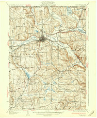
1932 Map of Corry
USGS Topo · Published 1932About this map
The rail junction of Corry serves as the industrial and logistical anchor for this northwestern Pennsylvania landscape, where the Pennsylvania Railroad and Erie Railroad converge. The 1932 topography reveals a countryside densely patterned with small rural schools, such as Wheelock Sch and Stedman Sch, illustrating the dispersed settlement pattern of Wayne and Columbus townships before mid-century consolidation. The terrain is defined by the winding course of French Creek and its many tributaries, including South Branch French Creek, which drain a complex of wetlands like Tamarack Swamp and Benson Swamp. Genealogists will find a wealth of specific landmarks, from Pine Valley Cem near the New York border to family-named corners like Mertz Corners and Blakeslee Corners. Smaller communities such as Spartansburg, Elgin, and Bear Lake appear at their early twentieth-century peak, linked by the Roosevelt Highway.
Find a feature on this map
103 named features on this map. Tap any name to fly to it.
Don’t see what you’re looking for? This feature index may not catch every label — zoom into the map to look around manually.
Map Details
Editions of this 1932 Corry Map
3 editions found

Other maps of this area

1904 · Chautaqua
USGS Topo · 1:62,500

1905 · Clymer
USGS Topo · 1:62,500

1913 · North East
USGS Topo · 1:62,500

1915 · North East
USGS Topo · 1:62,500

1926 · Youngsville
USGS Topo · 1:62,500

1927 · Townville
USGS Topo · 1:48,000

1927 · Tidioute
USGS Topo · 1:48,000

1927 · Titusville
USGS Topo · 1:62,500

1929 · Corry
USGS Topo · 1:48,000

1929 · Youngsville
USGS Topo · 1:62,500