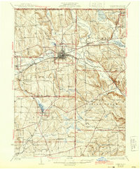
1932 Map of Corry
USGS Topo · Published 1944About this map
Corry serves as a significant rail hub where the Pennsylvania Railroad and Erie Railroad intersect, anchoring a landscape defined by the drainage basins of French Creek and Brokenstraw Creek. The 1930s settlement pattern is dense with named crossroads and rural communities like Spartansburg, Columbus, and Elgin. The industrial and agricultural vitality of the era is reflected in the extensive network of schoolhouses, such as Scotia Ch Sch and Sample Flats Sch, alongside remote landmarks like Tamarack Swamp and Benson Swamp. This survey offers a clear view of the borderlands between Erie, Crawford, and Warren counties before modern highway expansion altered the smaller hamlets. Numerous family-named hills and runs, including Mickel Hill and Whitney Run, provide specific points of interest for genealogists tracing ancestral landholdings in northwestern Pennsylvania during the pre-war years.
Find a feature on this map
109 named features on this map. Tap any name to fly to it.
Don’t see what you’re looking for? This feature index may not catch every label — zoom into the map to look around manually.
Map Details
Editions of this 1932 Corry Map
3 editions found

Other maps of this area

1904 · Chautaqua
USGS Topo · 1:62,500

1905 · Clymer
USGS Topo · 1:62,500

1913 · North East
USGS Topo · 1:62,500

1915 · North East
USGS Topo · 1:62,500

1926 · Youngsville
USGS Topo · 1:62,500

1927 · Townville
USGS Topo · 1:48,000

1927 · Tidioute
USGS Topo · 1:48,000

1927 · Titusville
USGS Topo · 1:62,500

1929 · Corry
USGS Topo · 1:48,000

1929 · Youngsville
USGS Topo · 1:62,500