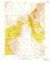
1938 Map of Cortez
USGS Topo · Published 1955About this map
The high desert mining landscape of the Cortez Mountains dominates this 1938 survey, illustrating the proximity of industrial operations to isolated ranching life. Centered around the prominent Mt Tenabo, the map documents several active extraction sites including the Cortez Mine, Mill Canyon Mine, and a Turquoise Mine. The rugged topography transitions sharply into the broad reaches of Crescent Valley and Grass Valley, where water sources like Wenban Spring and Dugout Spring were essential for sustaining the remote outposts of the era.
Find a feature on this map
30 named features on this map. Tap any name to fly to it.
Don’t see what you’re looking for? This feature index may not catch every label — zoom into the map to look around manually.
Map Details
Editions of this 1938 Cortez Map
4 editions found
Other maps of this area

1926 · Roberts Mountains
USGS Topo · 1:250,000

1929 · Roberts Mountains
USGS Topo · 1:250,000

1938 · Cortez
USGS Topo · 1:48,000

1944 · Cortez
USGS Topo · 1:62,500

1949 · Crescent Valley
USGS Topo · 1:62,500

1949 · Mt. Lewis
USGS Topo · 1:62,500

1949 · Roberts Creek Mtn
USGS Topo · 1:62,500

1950 · Mt. Lewis
USGS Topo · 1:62,500

1950 · Crescent Valley
USGS Topo · 1:62,500

1951 · Roberts Creek Mtn
USGS Topo · 1:62,500