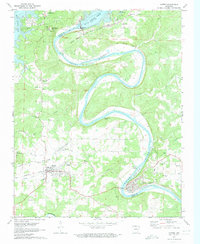
1972 Map of Cotter
USGS Topo · Published 1973About this map
The White River carves a massive, winding path through this North Arkansas landscape, punctuated by the engineering of the Bull Shoals Dam and its expansive Bull Shoals Lake. The river's influence is evident in the transition from the high elevations of Bull Shoals Mountain to the alluvial flats near McBee Landing. Transport networks define the local economy, with the Missouri Pacific railroad running parallel to the river and connecting the town of Cotter to Flippin further west.
Find a feature on this map
52 named features on this map. Tap any name to fly to it.
Don’t see what you’re looking for? This feature index may not catch every label — zoom into the map to look around manually.
Map Details
Editions of this 1972 Cotter Map
3 editions found
Other maps of this area

1890 · Mountain Home
USGS Topo · 1:125,000

1891 · Mountain Home
USGS Topo · 1:125,000

1893 · Yellville
USGS Topo · 1:125,000

1894 · Mountain Home
USGS Topo · 1:125,000

1903 · Yellville
USGS Topo · 1:125,000

1905 · Yellville
USGS Topo · 1:125,000

1929 · Yellville
USGS Topo · 1:125,000

1945 · Harrison
USGS Topo · 1:250,000

1949 · Harrison
USGS Topo · 1:250,000

1954 · Harrison
USGS Topo · 1:250,000