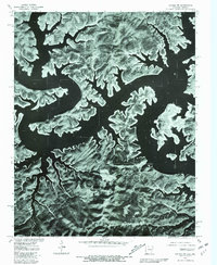
1979 Map of Cotter NW
USGS Topo · Published 1981About this map
Bull Shoals Lake dominates this orthophotomap, showing the dendritic shoreline of the reservoir as it appeared in the late 1970s. This aerial perspective, produced in cooperation with the Soil Conservation Service, provides a detailed look at the interface between the wooded uplands and the submerged river valleys of the White River system. The small settlement of Midway is visible in the southern portion of the quadrangle, situated along the ridges above the rising water. The imagery reveals the intricate pattern of fingers and coves that characterize this portion of northern Arkansas, where the landscape was fundamentally altered by mid-century dam projects. Researchers can examine the road patterns and land use surrounding the lake, tracing how the local infrastructure adapted to the reservoir's complex geography.
Find a feature on this map
4 named features on this map. Tap any name to fly to it.
Don’t see what you’re looking for? This feature index may not catch every label — zoom into the map to look around manually.
Map Details
Editions of this 1979 Cotter NW Map
This is the sole edition of this map. No revisions or reprints were ever made.
Other maps of this area

1893 · Yellville
USGS Topo · 1:125,000

1903 · Yellville
USGS Topo · 1:125,000

1905 · Yellville
USGS Topo · 1:125,000

1929 · Yellville
USGS Topo · 1:125,000

1936 · Thornfield
USGS Topo · 1:48,000

1943 · Protem
USGS Topo · 1:62,500

1943 · Thornfield
USGS Topo · 1:62,500

1945 · Harrison
USGS Topo · 1:250,000

1945 · Thornfield
USGS Topo · 1:62,500

1949 · Harrison
USGS Topo · 1:250,000