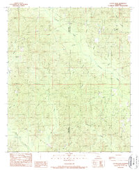
1989 Map of Cotton Plant
USGS Topo · Published 1989About this map
Winn Parish and Caldwell Parish meet along a landscape defined by an intricate network of drainage and local timber history. This late-1980s survey captures small, dispersed communities like Cotton Plant and Chester before major modern redevelopments changed the rural character of northern Louisiana. The presence of an Old RR Grade running near Beaucoup Branch indicates a legacy of industrial transport, likely related to the region's logging era, while numerous smaller waterways such as Cypress Creek, Morgan Creek, and Messer Creek segment the terrain. For genealogists, the map identifies specific points of interest like a Cem and the settlement at Newport. The drainage patterns, particularly around Big Creek and Flat Creek, illustrate the transition from upland ridges to the bottomlands that shaped the early settlement and agricultural potential of this parish-line region.
Find a feature on this map
24 named features on this map. Tap any name to fly to it.
Don’t see what you’re looking for? This feature index may not catch every label — zoom into the map to look around manually.
Map Details
Editions of this 1989 Cotton Plant Map
This is the sole edition of this map. No revisions or reprints were ever made.
Other maps of this area

1940 · Columbia
USGS Topo · 1:62,500

1953 · Alexandria
USGS Topo · 1:250,000

1954 · Sikes
USGS Topo · 1:62,500

1954 · Tullos
USGS Topo · 1:62,500

1955 · Shreveport
USGS Topo · 1:250,000

1955 · Alexandria
USGS Topo · 1:250,000

1955 · Olla
USGS Topo · 1:62,500

1956 · Shreveport
USGS Topo · 1:250,000

1957 · Columbia
USGS Topo · 1:62,500

1984 · Shreveport
USGS Topo · 1:250,000