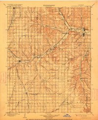
1898 Map of Cottonwood Falls
USGS Topo · Published 1915About this map
Cottonwood River and its South Fork define the settlement patterns of this central Kansas landscape, where the Atchison Topeka and Santa Fe RR follows the water's natural path through the valley. The map reveals a network of small agricultural hubs such as Strong, Elmdale, and Florence, each positioned to serve the surrounding Flint Hills cattle country. This period captures the region's transition from open prairie to a grid-based township system, with established communities like Cottonwood Falls and Lincolnville serving as focal points for trade and transportation.
Find a feature on this map
70 named features on this map. Tap any name to fly to it.
Don’t see what you’re looking for? This feature index may not catch every label — zoom into the map to look around manually.
Map Details
Editions of this 1898 Cottonwood Falls Map
4 editions found

Other maps of this area

1885 · Eskridge
USGS Topo · 1:125,000

1885 · Eureka
USGS Topo · 1:125,000

1888 · Emporia
USGS Topo · 1:125,000

1888 · Eureka
USGS Topo · 1:125,000

1888 · Eldorado
USGS Topo · 1:125,000

1889 · Newton
USGS Topo · 1:125,000

1889 · Abilene
USGS Topo · 1:125,000

1889 · Parkerville
USGS Topo · 1:125,000

1889 · Eskridge
USGS Topo · 1:125,000

1889 · Wichita
USGS Topo · 1:125,000