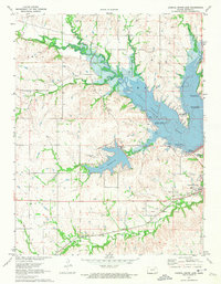
1971 Map of Council Grove Lake
USGS Topo · Published 1974About this map
The Old Indian Treaty Boundary slices across the landscape south of the Neosho River, marking a deep historical layer beneath this 1970s topographic record. The newly expanded waters of Council Grove Lake dominate the northern terrain, submerging the former confluence of Munkers Creek and the Neosho. At the lake's southern edge, the City Reservoir and various recreation areas, such as the Canning Creek Cove Recreation Area, illustrate the transition of this river valley into a managed water resource and parkland.
Find a feature on this map
28 named features on this map. Tap any name to fly to it.
Don’t see what you’re looking for? This feature index may not catch every label — zoom into the map to look around manually.
Map Details
Editions of this 1971 Council Grove Lake Map
This is the sole edition of this map. No revisions or reprints were ever made.
Other maps of this area

1885 · Eskridge
USGS Topo · 1:125,000

1889 · Parkerville
USGS Topo · 1:125,000

1889 · Eskridge
USGS Topo · 1:125,000

1894 · Eskridge
USGS Topo · 1:125,000

1894 · Parkerville
USGS Topo · 1:125,000

1955 · Hutchinson
USGS Topo · 1:250,000

1959 · Hutchinson
USGS Topo · 1:250,000

1971 · Alta Vista
USGS Topo · 1:24,000
1971 · Dwight
USGS Topo · 1:24,000
1971 · Council Grove
USGS Topo · 1:24,000