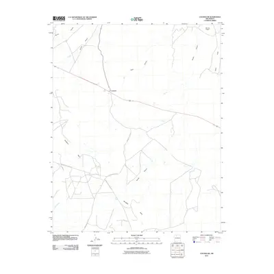
2010 Map of Counselor
USGS Topo · Published 2010About this map
Counselor serves as the primary settlement on this high-desert plateau within the Eastern Navajo Agency, positioned along a major arterial road. The landscape is defined by the massive Sisnathyel Mesa and a network of deep drainage systems including Escrito Canyon, Venado Canyon, and Largo Cañon. This 2010 survey highlights the infrastructure of the San Juan Basin Gas Field, illustrating how energy extraction has integrated with the traditional geography of the region. A series of indigenous thoroughfares, such as Indian Service Rte 46 and Indian Service Route 471, crisscross the territory, connecting isolated points across the rugged topography. These roads trace the natural contours of the land, leading toward seasonal watercourses like Cañada Alemita and providing essential access through the arid basin environment.
Find a feature on this map
12 named features on this map. Tap any name to fly to it.
Don’t see what you’re looking for? This feature index may not catch every label — zoom into the map to look around manually.
Map Details
Editions of this 2010 Counselor Map
This is the sole edition of this map. No revisions or reprints were ever made.
Other maps of this area

1889 · Largo
USGS Topo · 1:250,000

1895 · Largo
USGS Topo · 1:250,000

1954 · Aztec
USGS Topo · 1:250,000

1958 · Aztec
USGS Topo · 1:250,000

1959 · Nageezi
USGS Topo · 1:62,500

1962 · Aztec
USGS Topo · 1:250,000

1963 · Tayfoya Canyon
USGS Topo · 1:24,000

1963 · Otero Store
USGS Topo · 1:24,000

1965 · Aztec
USGS Topo · 1:250,000
1966 · Tancosa Windmill
USGS Topo · 1:24,000
Featured Places
- Eastern Navajo Agency, NM
- Counselor, Eastern Navajo Agency
- Sandoval County, NM
- Rio Arriba County, NM
- United States