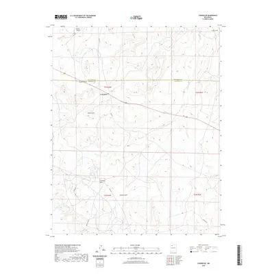
2020 Map of Counselor
USGS Topo · Published 2020About this map
Counselor serves as a focal point in this high-desert landscape, situated along the county line where Rio Arriba Co meets Sandoval Co. The terrain is defined by a network of drainage systems, including the prominent Cañon Largo in the northeast and the winding paths of Escrito Canyon, Haynes Canyon, and Gallo Canyon. To the south, the flat-topped Sisnathyel Mesa overlooks Venado Canyon and the headwaters of Cañada Alemita. This 2020 survey illustrates the modern road network essential for navigating this expansive area, highlighting routes such as Keetso Rd, Indian Svc Rte 46, and Jicarilla Rd. The geography reflects a sparsely populated region of the Eastern Navajo Agency, where the land's natural contours and seasonal watercourses dictate the placement of transportation corridors and small-scale settlement patterns.
Find a feature on this map
19 named features on this map. Tap any name to fly to it.
Don’t see what you’re looking for? This feature index may not catch every label — zoom into the map to look around manually.
Map Details
Editions of this 2020 Counselor Map
This is the sole edition of this map. No revisions or reprints were ever made.
Other maps of this area

1889 · Largo
USGS Topo · 1:250,000

1895 · Largo
USGS Topo · 1:250,000

1954 · Aztec
USGS Topo · 1:250,000

1958 · Aztec
USGS Topo · 1:250,000

1959 · Nageezi
USGS Topo · 1:62,500

1962 · Aztec
USGS Topo · 1:250,000

1963 · Tayfoya Canyon
USGS Topo · 1:24,000

1963 · Otero Store
USGS Topo · 1:24,000

1965 · Aztec
USGS Topo · 1:250,000
1966 · Tancosa Windmill
USGS Topo · 1:24,000
Featured Places
- Eastern Navajo Agency, NM
- Counselor, Eastern Navajo Agency
- Sandoval County, NM
- Rio Arriba County, NM
- United States