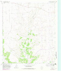
1964 Map of Coupe Ranch
USGS Topo · Published 1982About this map
Coupe Ranch and its neighboring livestock operations define the landscape of Schleicher County in this mid-1960s survey, updated with purple photorevisions from the late 1970s. The terrain is dominated by the winding path of Granger Draw, which cuts through the central portion of the sheet near Mayer Ranch and its associated Landing Strip. The presence of several family-named properties, including Speck Ranch to the north and Meador Ranch to the south, reflects the enduring ranching heritage of the Edwards Plateau.
Find a feature on this map
12 named features on this map. Tap any name to fly to it.
Don’t see what you’re looking for? This feature index may not catch every label — zoom into the map to look around manually.
Map Details
Editions of this 1964 Coupe Ranch Map
2 editions found
Other maps of this area

1954 · Sonora
USGS Topo · 1:250,000

1958 · Sonora
USGS Topo · 1:250,000

1964 · Eldorado NW
USGS Topo · 1:24,000

1964 · Eldorado SW
USGS Topo · 1:24,000

1964 · Oglesby Ranch
USGS Topo · 1:24,000

1964 · Sonora NW
USGS Topo · 1:24,000

1964 · Coupe Ranch
USGS Topo · 1:24,000

1964 · Bailey Draw
USGS Topo · 1:24,000

1964 · Moore Ranch
USGS Topo · 1:24,000

1967 · Nolen Draw
USGS Topo · 1:24,000