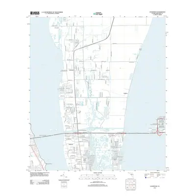
2012 Map of Courtenay
USGS Topo · Published 2012About this map
Saint Luke's Parish Episcopal Church Cem and Bethel Cem stand as early community landmarks on Merritt Island, anchoring the settlements of Courtenay and Audubon between the broad reaches of the Indian River and the Banana River. This coastal landscape, defined by intricate waterways like Sykes Creek and Flatboat Creek, reflects a modern era of space-age infrastructure and maritime development. The Christa McAuliffe Bridge connects the island to the mainland, while the eastern edge of the survey reveals the heavy industrial footprint of the cruise industry at the West Basin. Genealogical interest is concentrated in established neighborhoods like Indianola and Magnolia Point, while specialized facilities such as Central Telemetry highlight the region's unique role in aerospace operations. From the northern point of Pine Island to the sprawling docks of the Harbortown Marina at Canaveral, the map captures a period of significant density and nautical activity.
Find a feature on this map
141 named features on this map. Tap any name to fly to it.
Don’t see what you’re looking for? This feature index may not catch every label — zoom into the map to look around manually.
Map Details
Editions of this 2012 Courtenay Map
This is the sole edition of this map. No revisions or reprints were ever made.
Other maps of this area

1949 · Orsino
USGS Topo · 1:24,000

1949 · False Cape
USGS Topo · 1:24,000

1949 · Titusville
USGS Topo · 1:24,000

1949 · Courtenay
USGS Topo · 1:24,000

1949 · Sharpes
USGS Topo · 1:24,000

1949 · Cocoa
USGS Topo · 1:24,000

1949 · Cocoa Beach
USGS Topo · 1:24,000

1951 · False Cape
USGS Topo · 1:24,000

1951 · Cocoa
USGS Topo · 1:24,000

1951 · Courtenay
USGS Topo · 1:24,000