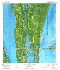
1976 Map of Courtenay
USGS Topo · Published 1977About this map
Merritt Island is defined by its dual identity as a space-age threshold and a preservation corridor in this 1976 orthophotomap. The eastern half is dominated by the John F Kennedy Space Center (NASA) and the Merritt Island National Wildlife Refuge, where the Space Center Bdy meets the marshy edges of the Banana River. To the west, the landscape transitions into established riverside communities along the Indian River. Residents and researchers can trace the older settlement patterns of Courtenay and Indianola, marked by landmarks like Orsino Ch, Mt Zion Ch, and Palm Chapel. The engineering of the mid-century is evident in the straight cut of the Canaveral Barge Canal and the Bennett Causeway, which link the island to Cocoa and City Pt. This map captures the region just as the space program's physical footprint had fully integrated with the local geography.
Find a feature on this map
43 named features on this map. Tap any name to fly to it.
Don’t see what you’re looking for? This feature index may not catch every label — zoom into the map to look around manually.
Map Details
Editions of this 1976 Courtenay Map
This is the sole edition of this map. No revisions or reprints were ever made.
Other maps of this area

1949 · Orsino
USGS Topo · 1:24,000

1949 · False Cape
USGS Topo · 1:24,000

1949 · Titusville
USGS Topo · 1:24,000

1949 · Courtenay
USGS Topo · 1:24,000

1949 · Sharpes
USGS Topo · 1:24,000

1949 · Cocoa
USGS Topo · 1:24,000

1949 · Cocoa Beach
USGS Topo · 1:24,000

1951 · False Cape
USGS Topo · 1:24,000

1951 · Cocoa
USGS Topo · 1:24,000

1951 · Courtenay
USGS Topo · 1:24,000