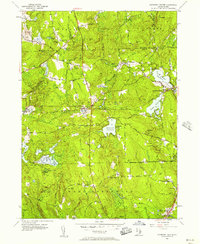
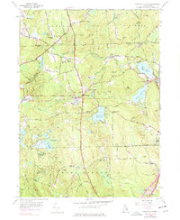
1955 Map of Coventry Center
USGS Topo · Published 1957About this map
The hills and river valleys of western Rhode Island define this landscape, where the New York New Haven and Hartford rail line cuts across the center of the sheet through small villages like Greene and Summit. The area's mid-century character is shaped by a mix of rural infrastructure and industry, including the Jackson Quarry and the Western Coventry Sch. Large tracts of protected land, notably the Wickaboxet State Forest, cover much of the southern terrain, while the northern sections are marked by family-named landmarks such as Mt Vernon Hill and Biscuit Hill. Water management for local mills and downstream use is evident in the elaborate system of reservoirs and ponds, particularly the Flat River Reservoir and Quidnick Reservoir. This survey captures the transition from traditional agrarian life to modern infrastructure, centered on the historic settlement at Coventry Center.
Find a feature on this map
55 named features on this map. Tap any name to fly to it.
Don’t see what you’re looking for? This feature index may not catch every label — zoom into the map to look around manually.
Map Details
Editions of this 1955 Coventry Center Map
5 editions found
Other maps of this area

1889 · Putnam
USGS Topo · 1:62,500

1889 · Burrillville
USGS Topo · 1:62,500

1889 · Moosup
USGS Topo · 1:62,500

1890 · Kent
USGS Topo · 1:62,500

1893 · Putnam
USGS Topo · 1:62,500

1893 · Moosup
USGS Topo · 1:62,500

1894 · Burrillville
USGS Topo · 1:62,500

1894 · Kent
USGS Topo · 1:62,500

1915 · Burrillville
USGS Topo · 1:62,500

1919 · Putnam
USGS Topo · 1:62,500