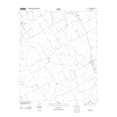
2012 Map of Covington
USGS Topo · Published 2012About this map
Covington and Rio Vista anchor this portion of the North Texas plains, where a web of county roads connects long-standing rural communities. The landscape is defined by the headwaters and branches of the Aquilla Cr and Mustang Cr systems, including Gourd Neck Br and Darr Br. Small, local airfields like Cow Pasture Airport and Birdnest Airport dot the countryside, reflecting the region's agricultural aviation and light aircraft culture. Genealogists will find significant value in the scattered burial grounds that mark early family settlements, such as Hart Cem, Parker Cem, Kinard Cem, and Ross Cem. The presence of smaller junctions like Derden and Woodrow highlights the persistent, decentralized settlement pattern of Hill and Johnson counties in the early twenty-first century, anchored by physical landmarks like the prominent Brushy Knob.
Find a feature on this map
82 named features on this map. Tap any name to fly to it.
Don’t see what you’re looking for? This feature index may not catch every label — zoom into the map to look around manually.
Map Details
Editions of this 2012 Covington Map
This is the sole edition of this map. No revisions or reprints were ever made.
Other maps of this area

1891 · Cleburne
USGS Topo · 1:125,000

1894 · Cleburne
USGS Topo · 1:125,000

1924 · Cleburne 3-B
USGS Topo · 1:48,000

1924 · Cleburne 3-C
USGS Topo · 1:48,000

1927 · Blum
USGS Topo · 1:62,500

1954 · Dallas
USGS Topo · 1:250,000

1958 · Dallas
USGS Topo · 1:250,000

1960 · Cleburne East
USGS Topo · 1:24,000
1961 · Cleburne West
USGS Topo · 1:24,000
1961 · Grandview
USGS Topo · 1:24,000