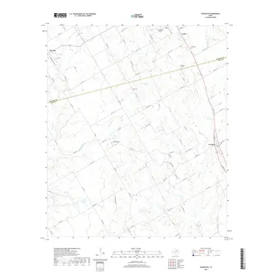
2019 Map of Covington
USGS Topo · Published 2019About this map
Covington and the surrounding prairie of the Johnson Co and Hill Co line are defined by a network of rural roads and creek drainages in this modern survey. The landscape is dotted with ancestral burial sites including Hart Cem, Parker Cem, Kinard Cem, and Ross Cem, which serve as vital markers for genealogical research in this part of Texas. North of the community of Parker, the terrain is punctuated by small private landing strips such as Birdnest Airport and Cow Pasture Airport, reflecting the region's agricultural and general aviation character. The hydrology is dominated by the winding paths of Aquilla Cr and Mustang Cr, while Brushy Knob provides one of the few distinct topographic elevations in the area. This survey captures the enduring rural settlement pattern of the region, where family names are often preserved in the local road designations and small communities.
Find a feature on this map
75 named features on this map. Tap any name to fly to it.
Don’t see what you’re looking for? This feature index may not catch every label — zoom into the map to look around manually.
Map Details
Editions of this 2019 Covington Map
This is the sole edition of this map. No revisions or reprints were ever made.
Other maps of this area

1891 · Cleburne
USGS Topo · 1:125,000

1894 · Cleburne
USGS Topo · 1:125,000

1924 · Cleburne 3-B
USGS Topo · 1:48,000

1924 · Cleburne 3-C
USGS Topo · 1:48,000

1927 · Blum
USGS Topo · 1:62,500

1954 · Dallas
USGS Topo · 1:250,000

1958 · Dallas
USGS Topo · 1:250,000

1960 · Cleburne East
USGS Topo · 1:24,000
1961 · Cleburne West
USGS Topo · 1:24,000
1961 · Grandview
USGS Topo · 1:24,000