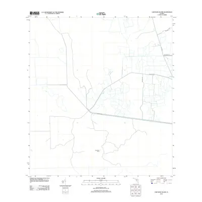
2012 Map of Cow Bone Island
USGS Topo · Published 2012About this map
Cow Bone Island sits within a managed landscape defined by water control and agricultural road networks in this modern survey of Collier County. The prominent W Feeder Canal cuts a straight path across the southern half of the quadrangle, illustrating the hydrological engineering essential to this region. The northern and eastern sections show a pattern of rural development and land use, marked by specific family and regional names such as McDaniels Rnch and Billy Fraser Rd. This grid of access roads, including Co Hwy 833 and Bia Hwy 1299, connects isolated parcels of land, reflecting the ongoing intersection of private ranching and tribal lands in the Florida interior. The transition from open terrain to structured agricultural plots is clearly visible through the road layouts and drainage features.
Find a feature on this map
8 named features on this map. Tap any name to fly to it.
Don’t see what you’re looking for? This feature index may not catch every label — zoom into the map to look around manually.
Map Details
Editions of this 2012 Cow Bone Island Map
This is the sole edition of this map. No revisions or reprints were ever made.
Other maps of this area

1956 · West Palm Beach
USGS Topo · 1:250,000

1957 · West Palm Beach
USGS Topo · 1:250,000

1958 · West Palm Beach
USGS Topo · 1:250,000

1974 · Everglades 2 SW
USGS Topo · 1:24,000

1974 · Immokalee 4 NW
USGS Topo · 1:24,000

1974 · Immokalee 1 SW
USGS Topo · 1:24,000

1974 · Immokalee 1 SE
USGS Topo · 1:24,000

1974 · Immokalee 1 NE
USGS Topo · 1:24,000
1974 · Everglades 2 NW
USGS Topo · 1:24,000
1974 · Immokalee 4 NE
USGS Topo · 1:24,000