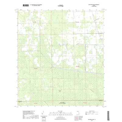
2018 Map of Cow Bone Island
USGS Topo · Published 2018About this map
Big Cypress National Preserve dominates this South Florida landscape, where a complex network of waterways and strands defines the interior of Hendry and Collier counties. The map details a transition between protected wilderness and managed lands, with the Florida National Scenic Trail winding through the southern reaches near Cow Bone Island. Large-scale water management is evident via the West Feeder Canal, while the presence of the Mc Daniels Ranch in the northeast corner represents the region's agricultural and ranching footprint.
Find a feature on this map
34 named features on this map. Tap any name to fly to it.
Don’t see what you’re looking for? This feature index may not catch every label — zoom into the map to look around manually.
Map Details
Editions of this 2018 Cow Bone Island Map
This is the sole edition of this map. No revisions or reprints were ever made.
Other maps of this area

1956 · West Palm Beach
USGS Topo · 1:250,000

1957 · West Palm Beach
USGS Topo · 1:250,000

1958 · West Palm Beach
USGS Topo · 1:250,000

1974 · Everglades 2 SW
USGS Topo · 1:24,000

1974 · Immokalee 4 NW
USGS Topo · 1:24,000

1974 · Immokalee 1 SW
USGS Topo · 1:24,000

1974 · Immokalee 1 SE
USGS Topo · 1:24,000

1974 · Immokalee 1 NE
USGS Topo · 1:24,000
1974 · Everglades 2 NW
USGS Topo · 1:24,000
1974 · Immokalee 4 NE
USGS Topo · 1:24,000