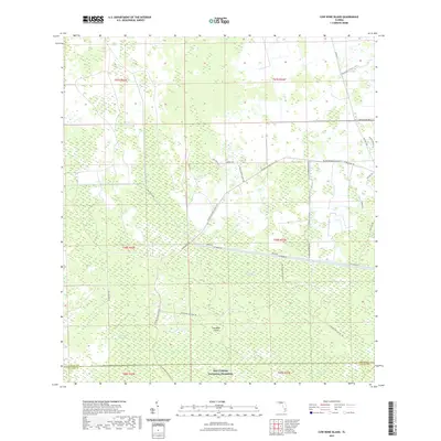
2021 Map of Cow Bone Island
USGS Topo · Published 2021About this map
Big Cypress National Preserve defines the southern reach of this Florida landscape, where the wetland ecology of the Everglades is mapped through intricate strands and sloughs. This 2021 survey documents a region defined by its hydrography, notably the West Feeder Canal and its associated W Feeder Rd, which bisect the terrain. The presence of Cow Bone Island and Kissimmee Billy Strand indicates the subtle elevation changes that dictate settlement and land use in these marshy reaches.
Find a feature on this map
35 named features on this map. Tap any name to fly to it.
Don’t see what you’re looking for? This feature index may not catch every label — zoom into the map to look around manually.
Map Details
Editions of this 2021 Cow Bone Island Map
This is the sole edition of this map. No revisions or reprints were ever made.
Other maps of this area

1956 · West Palm Beach
USGS Topo · 1:250,000

1957 · West Palm Beach
USGS Topo · 1:250,000

1958 · West Palm Beach
USGS Topo · 1:250,000

1974 · Everglades 2 SW
USGS Topo · 1:24,000

1974 · Immokalee 4 NW
USGS Topo · 1:24,000

1974 · Immokalee 1 SW
USGS Topo · 1:24,000

1974 · Immokalee 1 SE
USGS Topo · 1:24,000

1974 · Immokalee 1 NE
USGS Topo · 1:24,000
1974 · Everglades 2 NW
USGS Topo · 1:24,000
1974 · Immokalee 4 NE
USGS Topo · 1:24,000