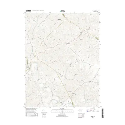
2016 Map of Cowan
USGS Topo · Published 2016About this map
The Bend of Licking anchors this area of Kentucky where the Licking River carves a deep loop through the landscape of the early 21st century. The map details a rural geography defined by its historic crossroads and small settlements like Cowan, Alhambra, and Fairview. Transport history is visible in the alignment of the Old Buffalo Trl and the crossing at Johnson Bridge, alongside more industrial remnants such as the Big Tunnel at Tunnel Hill. For genealogists, the map identifies several local burial sites including Sunnyside Cem, Standiford Cem, and Herndon Cem, often situated near family-named roads like Abners Mill Rd and Mint Ridge Rd. The confluence of Fleming Creek and Buchanan Creek further illustrates the complex drainage system of this border region where Nicholas, Robertson, Mason, and Fleming counties meet.
Find a feature on this map
77 named features on this map. Tap any name to fly to it.
Don’t see what you’re looking for? This feature index may not catch every label — zoom into the map to look around manually.
Map Details
Editions of this 2016 Cowan Map
This is the sole edition of this map. No revisions or reprints were ever made.
Other maps of this area

1915 · Maysville
USGS Topo · 1:62,500

1919 · Maysville
USGS Topo · 1:62,500

1952 · Cowan
USGS Topo · 1:24,000

1952 · Sherburne
USGS Topo · 1:24,000

1952 · Elizaville
USGS Topo · 1:24,000

1952 · Sardis
USGS Topo · 1:24,000

1952 · Mount Olivet
USGS Topo · 1:24,000

1952 · Piqua
USGS Topo · 1:24,000
1952 · Mays Lick
USGS Topo · 1:24,000

1953 · Carlisle
USGS Topo · 1:24,000