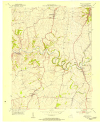
1952 Map of Mays Lick
USGS Topo · Published 1954About this map
The winding North Fork Licking River defines the center of this Mason County landscape, where the deeply incised river valley separates the uplands of Washington to the north from the southern settlement of Mays Lick. The mid-century transportation network is anchored by the Louisville and Nashville railroad corridor, which follows the path of Strodes Creek through Lewisburg. Local life is recorded through numerous small-scale landmarks, including the Lewisburg High Sch and a High Sch at Mays Lick.
Find a feature on this map
24 named features on this map. Tap any name to fly to it.
Don’t see what you’re looking for? This feature index may not catch every label — zoom into the map to look around manually.
Map Details
Editions of this 1952 Mays Lick Map
3 editions found
Other maps of this area

1915 · Maysville
USGS Topo · 1:62,500

1919 · Maysville
USGS Topo · 1:62,500

1929 · Springdale
USGS Topo · 1:48,000

1935 · Springdale
USGS Topo · 1:62,500

1951 · Flemingsburg
USGS Topo · 1:24,000

1952 · Cowan
USGS Topo · 1:24,000

1952 · Maysville East
USGS Topo · 1:24,000

1952 · Germantown
USGS Topo · 1:24,000

1952 · Elizaville
USGS Topo · 1:24,000

1952 · Maysville West
USGS Topo · 1:24,000