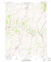
1952 Map of Mays Lick
USGS Topo · Published 1978About this map
The winding North Fork Licking River defines the rural landscape of central Mason County in this mid-century survey. Steeped in early Kentucky history, the map shows Washington at the northern edge and Mays Lick to the south, both significant nodes along the historical transportation routes of the Bluegrass region. The transition of the late 1940s and early 1950s is evident in the infrastructure, where the Louisville and Nashville rail line runs parallel to established roads, connecting smaller communities like Lewisburg and Marshall. Local genealogy and community life are grounded in the distribution of rural schools and resting places, such as the St Patrick Cem and Finch Cem. Cultural shifts of the era are punctuated by the emergence of new landmarks, including a Drive-in Theater situated on the eastern edge of the quadrangle.
Find a feature on this map
22 named features on this map. Tap any name to fly to it.
Don’t see what you’re looking for? This feature index may not catch every label — zoom into the map to look around manually.
Map Details
Editions of this 1952 Mays Lick Map
3 editions found
Other maps of this area

1915 · Maysville
USGS Topo · 1:62,500

1919 · Maysville
USGS Topo · 1:62,500

1929 · Springdale
USGS Topo · 1:48,000

1935 · Springdale
USGS Topo · 1:62,500

1951 · Flemingsburg
USGS Topo · 1:24,000

1952 · Cowan
USGS Topo · 1:24,000

1952 · Maysville East
USGS Topo · 1:24,000

1952 · Germantown
USGS Topo · 1:24,000

1952 · Elizaville
USGS Topo · 1:24,000

1952 · Maysville West
USGS Topo · 1:24,000