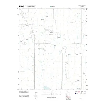
2009 Map of Cox City
USGS Topo · Published 2009About this map
Rush Creek and its many tributaries define this Stephens County landscape, where an extensive network of water management structures like the Rush Creek Site Number 21 Dam and Rush Creek Site 40 Dam coordinate the flow across the terrain. The map reveals a rural Oklahoma environment characterized by a precise grid of section line roads, including Goad Rd and N 2970 Rd, which provide access to family burial grounds and agricultural lands. Genealogists will find interest in the locations of Killgore Cemetery and Tidwell Cemetery, which sit as quiet landmarks among the drainages of Black Bear Creek and Fish Creek. This survey captures the specialized infrastructure of the region, from the Upper Clear Boggy Number 27 Dam in the south to the numerous numbered catchments that support the local watershed.
Find a feature on this map
40 named features on this map. Tap any name to fly to it.
Don’t see what you’re looking for? This feature index may not catch every label — zoom into the map to look around manually.
Map Details
Editions of this 2009 Cox City Map
This is the sole edition of this map. No revisions or reprints were ever made.
Other maps of this area

1902 · Rush Springs
USGS Topo · 1:125,000

1949 · Rush Springs
USGS Topo · 1:62,500

1950 · Rush Springs
USGS Topo · 1:62,500

1950 · Marlow
USGS Topo · 1:62,500

1951 · Marlow
USGS Topo · 1:62,500

1957 · Ardmore
USGS Topo · 1:250,000

1963 · Ardmore
USGS Topo · 1:250,000

1966 · Lindsay
USGS Topo · 1:24,000

1966 · Lindsay SW
USGS Topo · 1:24,000
1974 · Pernell
USGS Topo · 1:24,000