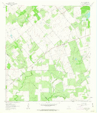
1961 Map of Coy City
USGS Topo · Published 1963About this map
Coy City sits at the heart of this South Texas landscape, where the borders of Karnes, Atascosa, and Live Oak counties converge. The terrain is defined by a dense network of seasonal drainages, including the prominent Escondido Creek and Weedy Creek, which carve a series of hollows across the brush country. The mid-century development of the region is evident in the presence of an extensive Pipeline network and several resource extraction sites like the Sludge Pit, Oil Well, and various Quarries. A notable Landing Strip south of the main settlement suggests the importance of aerial access in this rural area. Smaller communities such as Fashing appear on the western edge, connected by unimproved roads that trace the natural contours of Javancho Hollow and Mexican Hollow. This survey captures the transition of the South Texas plains into a managed industrial and agricultural landscape prior to further modern expansion.
Find a feature on this map
21 named features on this map. Tap any name to fly to it.
Don’t see what you’re looking for? This feature index may not catch every label — zoom into the map to look around manually.
Map Details
Editions of this 1961 Coy City Map
This is the sole edition of this map. No revisions or reprints were ever made.
Other maps of this area

1925 · Tordia No. 1
USGS Topo · 1:48,000

1931 · Falls City
USGS Topo · 1:62,500

1936 · Pettus
USGS Topo · 1:62,500

1953 · Crystal City
USGS Topo · 1:250,000

1953 · Beeville
USGS Topo · 1:250,000

1955 · Crystal City
USGS Topo · 1:250,000

1956 · Suniland
USGS Topo · 1:62,500

1956 · Beeville
USGS Topo · 1:250,000

1956 · Pettus
USGS Topo · 1:62,500

1956 · Karnes City
USGS Topo · 1:62,500