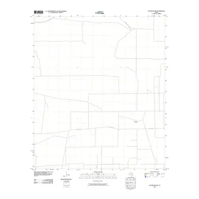
2010 Map of Coyanosa NW
USGS Topo · Published 2010About this map
The West Texas desert landscape near the Pecos County and Reeves County line is documented here in a 2010 study. Human activity is sparse, centered primarily on the sprawling ranching operations typical of the Trans-Pecos region. Weatherby Ranch serves as a primary landmark in the southeast, accessed by the long stretch of Weatherby Rd. The road network is strictly utilitarian, consisting of ranch access points like Holcomb Rape Ranch Rd crossing the northern territory. This map reveals the vast spatial organization of modern cattle ranching and land divisions in a corner of Texas where water and settlement are rare, providing a precise record of these family-named landholdings before further oil or energy infrastructure might alter the local geography.
Find a feature on this map
3 named features on this map. Tap any name to fly to it.
Don’t see what you’re looking for? This feature index may not catch every label — zoom into the map to look around manually.
Map Details
Editions of this 2010 Coyanosa NW Map
This is the sole edition of this map. No revisions or reprints were ever made.
Other maps of this area

1931 · Barstow
USGS Topo · 1:125,000

1954 · Pecos
USGS Topo · 1:250,000

1957 · Pecos
USGS Topo · 1:250,000

1963 · Ligon Ranch
USGS Topo · 1:24,000

1963 · Old X Ranch
USGS Topo · 1:24,000

1963 · Rio Pecos Ranch
USGS Topo · 1:24,000
1970 · Barstow 3 SE
USGS Topo · 1:24,000

1970 · Barstow 3 NE
USGS Topo · 1:24,000
1973 · Coyanosa NW
USGS Topo · 1:24,000
1974 · Coyanosa
USGS Topo · 1:24,000