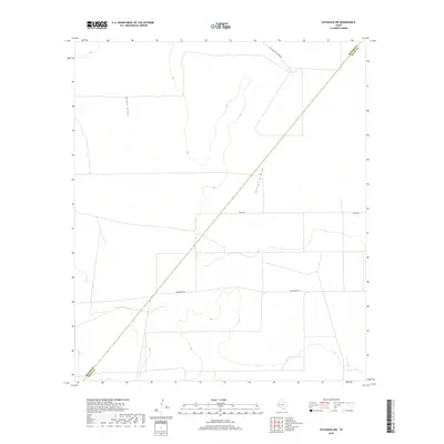
2019 Map of Coyanosa NW
USGS Topo · Published 2019About this map
Blake Draw and Hackberry Draw define the drainage patterns of this arid landscape at the edge of the Trans-Pecos region. In 2019, the terrain is marked by the long-standing diagonal boundary between Reeves and Pecos Counties, a line that cuts across the natural hydrology of the draws. The road network here reflects a ranching economy, with named routes like Holcomb Rape Ranch Rd, Tipton Rd, and Weatherby Rd providing access to the vast acreage of these West Texas ranch lands. The sparse development shown on this survey highlights the open, rural character of the area, where watercourses are the primary natural landmarks in an otherwise flat and expansive topography.
Find a feature on this map
6 named features on this map. Tap any name to fly to it.
Don’t see what you’re looking for? This feature index may not catch every label — zoom into the map to look around manually.
Map Details
Editions of this 2019 Coyanosa NW Map
This is the sole edition of this map. No revisions or reprints were ever made.
Other maps of this area

1931 · Barstow
USGS Topo · 1:125,000

1954 · Pecos
USGS Topo · 1:250,000

1957 · Pecos
USGS Topo · 1:250,000

1963 · Ligon Ranch
USGS Topo · 1:24,000

1963 · Old X Ranch
USGS Topo · 1:24,000

1963 · Rio Pecos Ranch
USGS Topo · 1:24,000
1970 · Barstow 3 SE
USGS Topo · 1:24,000

1970 · Barstow 3 NE
USGS Topo · 1:24,000
1973 · Coyanosa NW
USGS Topo · 1:24,000
1974 · Coyanosa
USGS Topo · 1:24,000