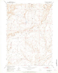
1952 Map of Coyote Springs
USGS Topo · Published 1965About this map
Beaver Rim dominates the landscape of this mid-century Fremont County survey, acting as a prominent geological escarpment that separates the northern drainages from the southern basins. The terrain is defined by a sparse but essential network of water sources, including Coyote Springs, Wild Horse Springs, and Mud Springs, which would have been critical landmarks for ranchers and travelers in this high desert environment. To the south, the land levels out into the Agate Flats, a region marked by ephemeral features such as The Dry Lakes. Evidence of mid-century industrial exploration is present in the form of a solitary Oil Well (Dry) located near the rim. The map also detail a complex system of seasonal watercourses like Black Rock Draw and Muskrat Creek, illustrating the natural drainage patterns of this Wyoming rangeland before modern development significantly altered the rural landscape.
Find a feature on this map
17 named features on this map. Tap any name to fly to it.
Don’t see what you’re looking for? This feature index may not catch every label — zoom into the map to look around manually.
Map Details
Editions of this 1952 Coyote Springs Map
4 editions found
Other maps of this area

1951 · Stampede Meadow
USGS Topo · 1:24,000

1951 · Black Rock Gap
USGS Topo · 1:24,000

1951 · Lankin Dome
USGS Topo · 1:24,000

1952 · Muskrat Basin
USGS Topo · 1:24,000

1952 · Rongis Reservoir SE
USGS Topo · 1:24,000

1952 · Gas Hills
USGS Topo · 1:24,000

1952 · Puddle Springs
USGS Topo · 1:24,000

1952 · Coyote Springs
USGS Topo · 1:24,000

1952 · Mc Intosh Meadows
USGS Topo · 1:24,000

1955 · Casper
USGS Topo · 1:250,000