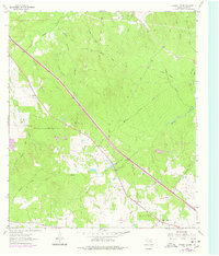
1963 Map of Crabbs Prairie
USGS Topo · Published 1978About this map
Crabbs Prairie sits at the heart of this landscape in Walker County, where the transition from agricultural clearing to timbered creek bottoms is clearly defined. The terrain is crisscrossed by an extensive network of the Old Railroad Grade, signaling a vanished era of timber or freight transport that once navigated the draws of Nelson Creek and Sulphur Branch. Local history and genealogy interest is anchored by the Cook Spring Ch and Petree Cem, which serve as permanent markers of the community's early settlement patterns. Industrial and infrastructure markers, such as a Claypit and a Lookout Tower, indicate the area's mixed use of resource extraction and forestry management. The presence of a Landing Strip and highway Rest Area facilities near the center of the sheet reflects the modernization of the corridor between larger Texas hubs during the mid-twentieth century.
Find a feature on this map
23 named features on this map. Tap any name to fly to it.
Don’t see what you’re looking for? This feature index may not catch every label — zoom into the map to look around manually.
Map Details
Editions of this 1963 Crabbs Prairie Map
2 editions found
Other maps of this area

1954 · Beaumont
USGS Topo · 1:250,000

1957 · Beaumont
USGS Topo · 1:250,000

1962 · Pine Prairie
USGS Topo · 1:24,000

1962 · Connor
USGS Topo · 1:24,000

1962 · Wyser Bottom
USGS Topo · 1:24,000

1962 · Galilee
USGS Topo · 1:24,000

1962 · Baker Lake
USGS Topo · 1:24,000

1963 · Steep Branch
USGS Topo · 1:24,000

1963 · Crabbs Prairie
USGS Topo · 1:24,000
1963 · Loma
USGS Topo · 1:24,000