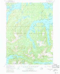
1949 Map of Craig B-2
USGS Topo · Published 1971About this map
Prince of Wales Island exhibits a landscape shaped by maritime access and early 20th-century industry on this mid-century survey. The settlement of Hollis is established on Twelvemile Arm, complete with a Seaplane Base reflecting the region's reliance on air and sea transport. Further south, the map records the decline of early industrial outposts, marking the inactive Khayyam Mine near McKenzie Inlet and the town of Sulzer, noted here as abandoned. This transition from active mining to post-frontier settlement is documented alongside numerous family-named points and topographical landmarks like Beaver Mountain and Rock Butte. The intricate shoreline of Kasaan Bay and Skowl Arm highlights the complex network of inlets and coves that defined the fishing and logging economy of the Tongass National Forest during this era.
Find a feature on this map
62 named features on this map. Tap any name to fly to it.
Don’t see what you’re looking for? This feature index may not catch every label — zoom into the map to look around manually.
Map Details
Editions of this 1949 Craig B-2 Map
3 editions found
Other maps of this area

1948 · Craig A-1
USGS Topo · 1:63,360

1948 · Craig A-3
USGS Topo · 1:63,360

1948 · Craig A-2
USGS Topo · 1:63,360

1949 · Craig C-2
USGS Topo · 1:63,360

1949 · Craig B-2
USGS Topo · 1:63,360

1949 · Craig B-3
USGS Topo · 1:63,360

1949 · Craig C-3
USGS Topo · 1:63,360

1949 · Craig B-1
USGS Topo · 1:63,360

1950 · Craig B-1
USGS Topo · 1:63,360

1950 · Craig C-1
USGS Topo · 1:63,360