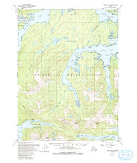
1949 Map of Craig B-2
USGS Topo · Published 1993About this map
The coastal deeps and interior ridges of Prince of Wales Island reveal a landscape defined by maritime industry and mining during the mid-20th century. This map traces the intricate shorelines of the Twelvemile Arm, Polk Inlet, and McKenzie Inlet, where the settlement of Hollis and the community of Kasaan on Kasaan Island served as vital water-access points. The rugged interior is marked by significant topography like Beaver Mountain and Barren Mtn, interspersed with isolated water bodies such as Rock Lake and Lake Mary. Historical industrial activity is visible at the Khayyam Mine near McKenzie Rk, while the presence of Sulzer (Aban'd) on the Sulzer Passage provides a specific point of interest for researchers tracking the decline of early mining outposts and remote coastal settlements.
Find a feature on this map
55 named features on this map. Tap any name to fly to it.
Don’t see what you’re looking for? This feature index may not catch every label — zoom into the map to look around manually.
Map Details
Editions of this 1949 Craig B-2 Map
3 editions found
Other maps of this area

1948 · Craig A-1
USGS Topo · 1:63,360

1948 · Craig A-3
USGS Topo · 1:63,360

1948 · Craig A-2
USGS Topo · 1:63,360

1949 · Craig C-2
USGS Topo · 1:63,360

1949 · Craig B-2
USGS Topo · 1:63,360

1949 · Craig B-3
USGS Topo · 1:63,360

1949 · Craig C-3
USGS Topo · 1:63,360

1949 · Craig B-1
USGS Topo · 1:63,360

1950 · Craig B-1
USGS Topo · 1:63,360

1950 · Craig C-1
USGS Topo · 1:63,360