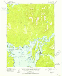
1951 Map of Craig C-4
USGS Topo · Published 1953About this map
Prince of Wales Island is defined by a labyrinth of fjords and intricate coastal topography in this early 1950s study. The settlement of Klawak, located along Klawak Inlet, serves as the primary focal point of human activity, featuring a Cem and Cemetery Pt at its periphery. The landscape transitions from the protected waters of San Alberto Bay to the high elevations of Kogish Mtn and Staney Cone further inland. A notable Pipe Line runs eastward toward Klawak Lake, indicating early industrial or utility infrastructure for the community. The presence of numerous islands, such as Wadleigh Island and Peratovitch Island, highlights the complex maritime navigation required to reach the interior waters of Big Salt Lake through the North Entrance and South Entrance.
Find a feature on this map
52 named features on this map. Tap any name to fly to it.
Don’t see what you’re looking for? This feature index may not catch every label — zoom into the map to look around manually.
Map Details
Editions of this 1951 Craig C-4 Map
2 editions found

Other maps of this area

1948 · Craig B-5
USGS Topo · 1:63,360

1949 · Craig D-3
USGS Topo · 1:63,360

1949 · Craig D-4
USGS Topo · 1:63,360

1949 · Craig B-3
USGS Topo · 1:63,360

1949 · Craig C-3
USGS Topo · 1:63,360

1949 · Craig C-4
USGS Topo · 1:63,360

1949 · Craig B-4
USGS Topo · 1:63,360

1950 · Craig D-3
USGS Topo · 1:63,360

1951 · Craig C-3
USGS Topo · 1:63,360

1951 · Craig B-4
USGS Topo · 1:63,360