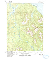
1949 Map of Craig D-3
USGS Topo · Published 1993About this map
Prince of Wales Island is depicted here in a period of transition, with coastal data updated in the mid-1980s overlaid on a 1949 topographic foundation. The landscape is defined by an intricate network of freshwater systems, including Sweetwater Lake and the branching Thorne River, which flows through the southern portion of the sheet toward Thorne Lake. Along the northeastern coast, Luck Pt and the Luck-Luck Point South Base mark the edge of the Clarence Strait, a vital maritime corridor. Interior features such as Manty Mountain and Baird Pk rise above a series of smaller alpine basins like Trumpeter Lake and Little Lake. Isolated human presence is noted at a Cabin near the shores of Sweetwater Lake, while the sheltered waters of Coffman Cove and the Gold and Galligan Lagoon suggest the region's reliance on marine access before the development of extensive inland infrastructure.
Find a feature on this map
24 named features on this map. Tap any name to fly to it.
Don’t see what you’re looking for? This feature index may not catch every label — zoom into the map to look around manually.
Map Details
Editions of this 1949 Craig D-3 Map
3 editions found
Other maps of this area

1948 · Petersburg A-2
USGS Topo · 1:63,360

1949 · Craig D-3
USGS Topo · 1:63,360

1949 · Craig C-2
USGS Topo · 1:63,360

1949 · Craig D-2
USGS Topo · 1:63,360

1949 · Petersburg A-3
USGS Topo · 1:63,360

1949 · Craig D-4
USGS Topo · 1:63,360

1949 · Petersburg A-4
USGS Topo · 1:63,360

1949 · Craig C-3
USGS Topo · 1:63,360

1949 · Craig C-4
USGS Topo · 1:63,360

1950 · Craig D-3
USGS Topo · 1:63,360