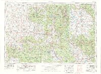
1954 Map of Craig
USGS Topo · Published 1976About this map
The Continental Divide zigzags through this mid-century look at Northwest Colorado, separating the headwaters of the North Platte River from the Colorado River basin. Following the 1974 revision, the landscape reveals a region defined by high-altitude cattle ranching and early energy development, particularly noted by the presence of Uranium Mines and the rail hub at Craig. The Denver and Rio Grande Western railroad serves as a vital artery through the Yampa River valley, connecting mountain outposts like Steamboat Springs and Phippsburg to the wider world. To the east, the high basin of North Park centers on Walden, surrounded by the Medicine Bow Mountains. The map provides a look at a wilderness transitioning into a recreational destination, with massive protected tracts like the Routt National Forest and the Mount Zirkel Wilderness established well before modern development took hold.
Find a feature on this map
94 named features on this map. Tap any name to fly to it.
Don’t see what you’re looking for? This feature index may not catch every label — zoom into the map to look around manually.
Map Details
Editions of this 1954 Craig Map
3 editions found

Other maps of this area

1895 · Laramie
USGS Topo · 1:125,000

1902 · Laramie
USGS Topo · 1:125,000

1905 · Laramie
USGS Topo · 1:125,000

1906 · Medicine Bow
USGS Topo · 1:125,000

1906 · Laramie
USGS Topo · 1:125,000

1906 · Grand Hogback
USGS Topo · 1:125,000

1907 · White River
USGS Topo · 1:125,000

1908 · Laramie
USGS Topo · 1:125,000

1908 · Medicine Bow
USGS Topo · 1:125,000

1910 · Danforth Hills
USGS Topo · 1:125,000