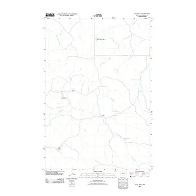
2011 Map of Crain Place
USGS Topo · Published 2011About this map
Crain Place serves as a primary geographic anchor in this section of Rosebud County, where the landscape is defined by a dendritic network of drainages and small-scale water management. Significant hydrological features include the Mees Number 1 Dam, Dunning Number 1 Dam, and Dunning Number 2 Dam, suggesting a reliance on seasonal runoff collection for ranching or agricultural sustainability. The terrain is deeply etched by various watercourses such as Twelvemile Creek, Bell Creek, and Eagle Creek, which converge and diverge across the quadrangle. Transportation is limited to a few arterial routes like Butte Creek Rd, highlighting the remote, pastoral character of the region. The presence of spring-fed sources like 04N44E28ACAA01 Spring further underscores the importance of localized water points in this semi-arid environment during the early 21st century.
Find a feature on this map
15 named features on this map. Tap any name to fly to it.
Don’t see what you’re looking for? This feature index may not catch every label — zoom into the map to look around manually.
Map Details
Editions of this 2011 Crain Place Map
This is the sole edition of this map. No revisions or reprints were ever made.
Other maps of this area
1954 · Hardin
USGS Topo · 1:250,000
1954 · Forsyth
USGS Topo · 1:250,000
1957 · Hardin
USGS Topo · 1:250,000
1957 · Forsyth
USGS Topo · 1:250,000
1958 · Forsyth
USGS Topo · 1:250,000
1958 · Hardin
USGS Topo · 1:250,000
1969 · Miller Creek SW
USGS Topo · 1:24,000
1969 · Miller Creek NW
USGS Topo · 1:24,000
1971 · Brandenberg NW
USGS Topo · 1:24,000
1971 · Hammond Draw NW
USGS Topo · 1:24,000