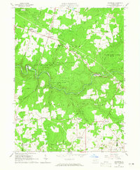
1963 Map of Cranberry
USGS Topo · Published 1965About this map
The New York Central rail line winds through a landscape defined by natural resource extraction and rural Pennsylvania settlement patterns in the early 1960s. Extensive Oil and Gas Fields and numerous strip mines dominate the terrain, particularly across the townships of Cranberry, Rockland, and Richland. This era shows a community transition, where traditional markers like the Township Sch and rural churches like St Catherines Ch exist alongside modern developments such as a Drive-in Theater and Deep Valley Park. The steep topography is carved by Sandy Creek and its many tributaries, including Twomile Run and Halls Run, while large tracts of State Game Lands No 45 preserve the wooded heights between scattered crossroads like Egypt Corners and Nickleville.
Find a feature on this map
45 named features on this map. Tap any name to fly to it.
Don’t see what you’re looking for? This feature index may not catch every label — zoom into the map to look around manually.
Map Details
Editions of this 1963 Cranberry Map
Other maps of this area

1907 · Foxburg
USGS Topo · 1:62,500

1908 · Foxburg
USGS Topo · 1:62,500

1909 · Franklin
USGS Topo · 1:62,500

1910 · Hilliards
USGS Topo · 1:62,500

1911 · Franklin
USGS Topo · 1:62,500

1912 · Hilliards
USGS Topo · 1:62,500

1922 · Oil City
USGS Topo · 1:48,000

1924 · Oil City
USGS Topo · 1:62,500

1943 · Oil City
USGS Topo · 1:62,500

1944 · Hilliards
USGS Topo · 1:62,500
Featured Places
- Cranberry Township, PA
- Rockland Township, PA
- Ashland Township, PA
- Richland Township, PA
- Salem Township, PA